
主管:中国科学院
主办:中国科学院古脊椎动物与古人类研究所
出版:科学出版社
主办:中国科学院古脊椎动物与古人类研究所
出版:科学出版社
人类学学报 ›› 2019, Vol. 38 ›› Issue (03): 407-418.doi: 10.16359/j.cnki.cn11-1963/q.2019.0038cstr: 32091.14.j.cnki.cn11-1963/q.2019.0038
张乐1,2,*( ), 张双权1,2,3, 高星1,2,3
收稿日期:2019-03-04
修回日期:2019-04-23
出版日期:2019-08-15
发布日期:2020-09-10
通讯作者:
张乐
作者简介:张乐(1980-),黑龙江牡丹江人,中国科学院古脊椎动物与古人类研究所,副研究员,E-Mail: 基金资助:
ZHANG Yue1,2,*(), ZHANG Shuangquan1,2,3, GAO Xing1,2,3
Received:2019-03-04
Revised:2019-04-23
Online:2019-08-15
Published:2020-09-10
Contact:
ZHANG Yue
摘要:
目前,地理信息系统(GIS)在多学科领域的融合方面已经发挥了极为明显的作用。但是,在动物考古学研究中,尤其是在东亚地区,这一手段的使用还明显有所欠缺。本文尝试将这一技术手段应用于贵州马鞍山遗址(距今约43~16 kaBP)出土动物遗存的研究之中。在上千件石制品与数十件骨制品之外,马鞍山遗址还出土有大量的动物化石,从而使其成为检验与实践地理信息系统的一个良好媒介。本文以ArcGIS软件包中的空间分析工具为技术依托,重点对遗址出土的大型动物(包括Bubalus sp 和 Megatapirus augustus) 的骨骼单元分布模式进行了更为准确的统计与分析。本项研究表明,相对于传统方法而言,GIS系统在大型动物遗存的量化统计方面具有独特而重要的价值;此外,这一技术手段还有望在第四纪其他学科的研究中得到发挥与应用。
中图分类号:
张乐, 张双权, 高星. 地理信息系统在动物考古学研究中的应用: 以贵州马鞍山遗址出土的动物遗存为例[J]. 人类学学报, 2019, 38(03): 407-418.
ZHANG Yue, ZHANG Shuangquan, GAO Xing. Geographic information system in zooarchaeology: A novel technique in analysis of the faunal remains from the Ma’anshan site, Guizhou, China[J]. Acta Anthropologica Sinica, 2019, 38(03): 407-418.
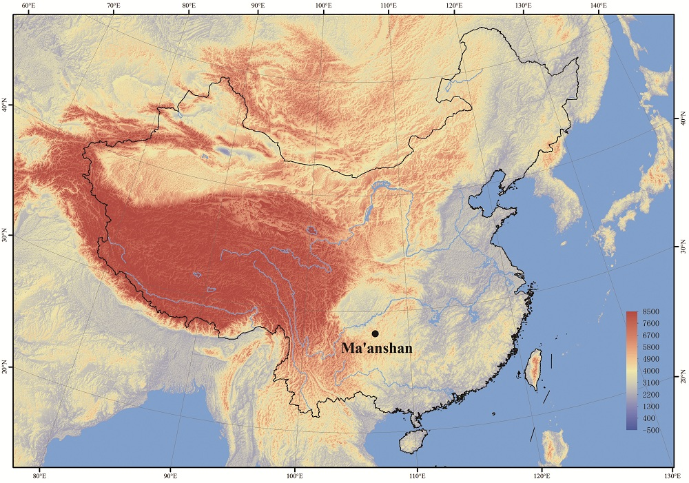
Fig.1 Geographical location of the Ma’anshan site
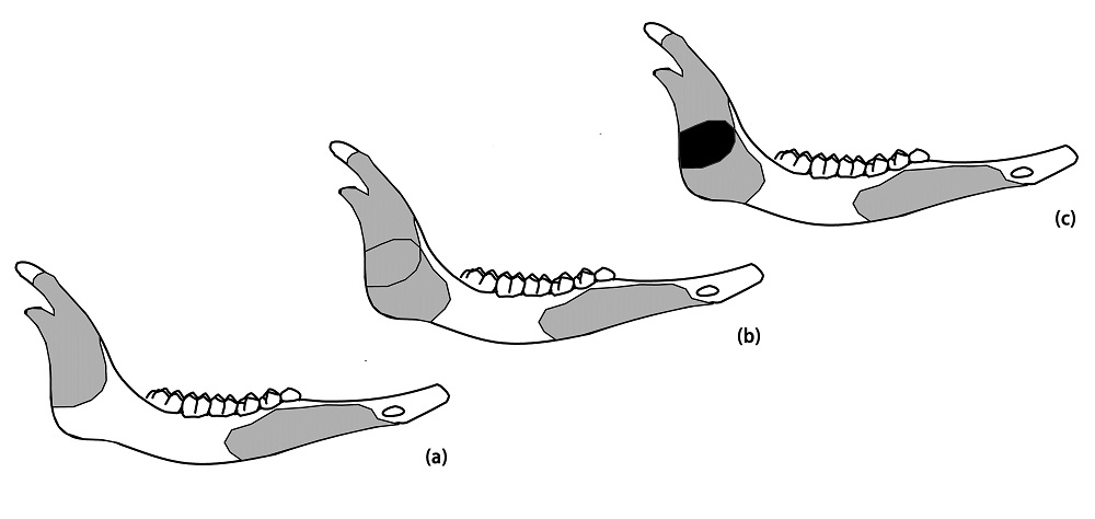
Fig.2 Schematic illustration of the principle of MNE quantification (a) two mandible fragments of a mammal taxon drawn onto the element, where the MNE count is 1 (although there are two pieces of bone); (b) a third fragment, sharing some identical features with one of the first two bones, is added to the mandible template; (c) the overlapping part between the two fragments(in black colour) now raises the MNE count from 1 to 2
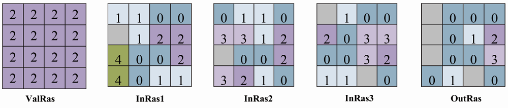
Fig.3 Schematic illustration of the computing process of the Equal to Frequency tool (modified after ESRI, 2014)
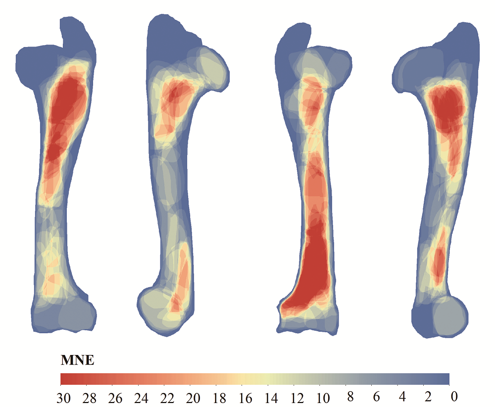
Fig.4 The MNE value for humerus of Bubalus sp. from the lower unit of Ma’anshan site
| Upper unit | Lower unit | |||||||||||
|---|---|---|---|---|---|---|---|---|---|---|---|---|
| NISP | MNE | MNE* | MAU | MAU% | MAU%* | NISP | MNE | MNE* | MAU | MAU% | MAU%* | |
| Cranium | 66 | 27 | 27 | 6 | 100 | 100 | 80 | 16 | 16 | 8 | 42.11 | 48.34 |
| Mandible | 7 | 3 | 2 | 1.5 | 25 | 16.67 | 33 | 8 | 8 | 4 | 21.05 | 24.17 |
| Rib | 51 | 10 | 8.32 | 0.38 | 6.41 | 5.33 | 81 | 15 | 11.44 | 0.58 | 3.04 | 2.66 |
| Scapula | 2 | 1 | 1.1 | 0.5 | 8.33 | 9.17 | 3 | 1 | 0.5 | 0.5 | 2.63 | 1.51 |
| Humerus | 32 | 3 | 3 | 1.5 | 25 | 25 | 187 | 30 | 23.4 | 15 | 78.95 | 70.69 |
| Radius/Ulna | 29 | 5 | 4 | 2.5 | 41.67 | 33.33 | 184 | 38 | 33.2 | 19 | 100 | 100 |
| Pelvis | 2 | 1 | 1 | 0.5 | 8.33 | 8.33 | 7 | 4 | 3 | 2 | 10.53 | 9.06 |
| Femur | 13 | 2 | 2 | 1 | 16.67 | 16.67 | 58 | 13 | 11.8 | 6.5 | 34.21 | 35.65 |
| Tiba | 24 | 7 | 6 | 3.5 | 58.33 | 50 | 107 | 17 | 14.86 | 8.5 | 44.74 | 44.89 |
| Astragulus | 18 | 4 | 4 | 2 | 33.33 | 50 | 28 | 12 | 11 | 6 | 31.58 | 36.25 |
| Metapodial | 48 | 9 | 8.8 | 2.25 | 37.5 | 36.67 | 92 | 16 | 14.76 | 4 | 21.05 | 22.3 |
| Phalange1 | 38 | 20 | 18.48 | 2.5 | 41.67 | 38.5 | 16 | 7 | 5.52 | 0.88 | 4.61 | 4.15 |
| Phalange2 | 30 | 14 | 12.8 | 1.75 | 29.17 | 26.7 | 8 | 7 | 6 | 0.88 | 4.61 | 4.5 |
| Phalange3 | 2 | 2 | 1.6 | 0.25 | 4.17 | 3.3 | 0 | 0 | 0 | 0 | 0 | 0 |
| Total | 362 | 884 | ||||||||||
Tab.1 Skeletal element data (NISP, MAU and MAU%) for Class III animals from the upper and lower units of Ma’anshan site. Note: Numbers in columns marked by “*” are values obtained via the traditional method, as published in Zhang et al[29]
| Upper unit | Lower unit | |||||||||||
|---|---|---|---|---|---|---|---|---|---|---|---|---|
| NISP | MNE | MNE* | MAU | MAU% | MAU%* | NISP | MNE | MNE* | MAU | MAU% | MAU%* | |
| Cranium | 66 | 27 | 27 | 6 | 100 | 100 | 80 | 16 | 16 | 8 | 42.11 | 48.34 |
| Mandible | 7 | 3 | 2 | 1.5 | 25 | 16.67 | 33 | 8 | 8 | 4 | 21.05 | 24.17 |
| Rib | 51 | 10 | 8.32 | 0.38 | 6.41 | 5.33 | 81 | 15 | 11.44 | 0.58 | 3.04 | 2.66 |
| Scapula | 2 | 1 | 1.1 | 0.5 | 8.33 | 9.17 | 3 | 1 | 0.5 | 0.5 | 2.63 | 1.51 |
| Humerus | 32 | 3 | 3 | 1.5 | 25 | 25 | 187 | 30 | 23.4 | 15 | 78.95 | 70.69 |
| Radius/Ulna | 29 | 5 | 4 | 2.5 | 41.67 | 33.33 | 184 | 38 | 33.2 | 19 | 100 | 100 |
| Pelvis | 2 | 1 | 1 | 0.5 | 8.33 | 8.33 | 7 | 4 | 3 | 2 | 10.53 | 9.06 |
| Femur | 13 | 2 | 2 | 1 | 16.67 | 16.67 | 58 | 13 | 11.8 | 6.5 | 34.21 | 35.65 |
| Tiba | 24 | 7 | 6 | 3.5 | 58.33 | 50 | 107 | 17 | 14.86 | 8.5 | 44.74 | 44.89 |
| Astragulus | 18 | 4 | 4 | 2 | 33.33 | 50 | 28 | 12 | 11 | 6 | 31.58 | 36.25 |
| Metapodial | 48 | 9 | 8.8 | 2.25 | 37.5 | 36.67 | 92 | 16 | 14.76 | 4 | 21.05 | 22.3 |
| Phalange1 | 38 | 20 | 18.48 | 2.5 | 41.67 | 38.5 | 16 | 7 | 5.52 | 0.88 | 4.61 | 4.15 |
| Phalange2 | 30 | 14 | 12.8 | 1.75 | 29.17 | 26.7 | 8 | 7 | 6 | 0.88 | 4.61 | 4.5 |
| Phalange3 | 2 | 2 | 1.6 | 0.25 | 4.17 | 3.3 | 0 | 0 | 0 | 0 | 0 | 0 |
| Total | 362 | 884 | ||||||||||
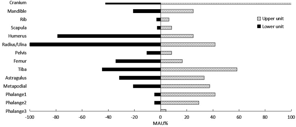
Fig.5 The skeletal element profiles of Class III animals from the upper and lower units at the Ma’anshan site
| [1] | Gaffney V, Stancic Z. GIS Approaches to Regional Analysis: a Case Study of the Island of Hvar[M]. Ljubljana: Research Institute of the Faculty of Arts & Science, University of Ljubljana, 1991 |
| [2] | Ebert D. Applications of archaeological GIS[J]. Canadian Journal Of Archaeology, 2004,28(2):319-341 |
| [3] | Scianna A, Villa B. GIS applications in archaeology[J]. Archeologia e Calcolatori, 2012,22:337-363 |
| [4] | García-Moreno A, Hutson J, Villaluenga A, et al. Counting sheep without falling asleep: using GIS to calculate the minimum number of skeletal elements(MNE) and other archaeozoological measures at Schöningen 13II-4 “Spear Horizon”[A]. In: Giligny F, Djindjian F, Costa L, et al(eds). CAA2014-21st Century Archaeology: Concepts, Methods and Tools. Proceedings of the 42nd Annual Conference on Computer Applications and Quantitative Methods in Archaeology[C]. Oxford: Archaeopress, 2015 |
| [5] | Parkinson JA. A GIS image analysis approach to documenting Oldowan hominin carcass acquisition: Evidence from Kanjera South, FLK Zinj, and neotaphonomic models of carnivore bone destruction[D]. Ph.D Dissertation. New York: City University of New York, 2013 |
| [6] | Fischer A. Computerised bone templates as the basis of a practical procedure to record and analyse graphical zooarchaeological data[J]. Revista Electrónica de Arqueología PUCP, 2007,2(1): |
| [7] |
Parkinson JA, Plummer T, Hartstone-Rose A. Characterizing felid tooth marking and gross bone damage patterns using GIS image analysis: An experimental feeding study with large felids[J]. Journal Of Human Evolution, 2015,80:114-134
URL pmid: 25467112 |
| [8] | Herrmann NP, Joanne BD, Jessica CS. Assessment of commingled human remains using a GIS-based and osteological landmark approach[A]. In: Bradley A, John B, eds. Commingled Human Remains: Methods in Recovery, Analysis, and Identification[C]. Amsterdam: Academic Press, 2014, 221-237 |
| [9] |
Parkinson JA, Plummer TW, Bose R. A GIS-based approach to documenting large canid damage to bones[J]. Palaeogeography, Palaeoclimatology, Palaeoecology, 2014,409:57-71
doi: 10.1016/j.palaeo.2014.04.019 URL |
| [10] |
Abe Y, Marean CW, Nilssen PJ, et al. The Analysis of Cutmarks on Archaeofauna: A Review and Critique of Quantification Procedures, and a New Image-Analysis GIS Approach[J]. American Antiquity, 2002,67(4):643-664
doi: 10.2307/1593796 URL |
| [11] |
Marean CW, Abe Y, Nilssen PJ, et al. Estimating the Minimum Number of Skeletal Elements(MNE) in Zooarchaeology: A Review and a New Image-Analysis GIS Approach[J]. American Antiquity, 2001,66(2):333-348
URL pmid: 20043371 |
| [12] | Nilssen PJ. An actualistic butchery study in South Africa and its implications for reconstructing hominid strategies of carcass acquisition and butchery in the Upper Pleistocene and Plio-Pleistocene[D]. Ph.D Dissertation. Cape Town: University of Cape Town, 2000 |
| [13] | Lyman RL. Vertebrate Taphonomy[M]. Cambridge: Cambridge University Press, 1994: 1-552 |
| [14] | Grayson DK. Quantitative Zooarchaeology: Topics in the Analysis of Archaeological Faunas[M]. Massachusetts: Academic Press, 1984 |
| [15] | Lyman RL. Quantitative Paleozoology[M]. New York: Cambridge University Press, 2008 |
| [16] | Marean CW, Domínguez-Rodrigo M, Pickering TR. Skeletal element equifinality in zooarchaeology begins with method: the evolution and status of the "shaft critique"[J]. Journal of Taphonomy, 2004,2(2):69-98 |
| [17] |
Faith JT, Gordon AD. Skeletal element abundances in archaeofaunal assemblages: economic utility, sample size, and assessment of carcass transport strategies[J]. Journal of Archaeological Science, 2007,34(6):872-882
doi: 10.1016/j.jas.2006.08.007 URL |
| [18] |
Faith JT, Domínguez-Rodrigo M, Gordon AD. Long-distance carcass transport at Olduvai Gorge? A quantitative examination of Bed I skeletal element abundances[J]. Journal Of Human Evolution, 2009,56(3):247-256
doi: 10.1016/j.jhevol.2008.12.008 URL pmid: 19211130 |
| [19] |
Zhang S, Li Z, Zhang Y, et al. Skeletal element distributions of the large herbivores from the Lingjing site, Henan Province, China[J]. Science China: Earth Sciences, 2012,55(2):246-253
doi: 10.1007/s11430-011-4279-x URL |
| [20] | Faith JT, Thompson JC. Low-survival skeletal elements track attrition, not carcass transport behavior in Quaternary large mammal assemblages[A]. In: Giovas CM, LeFebvre MJ, eds. Zooarchaeology in Practice: Case Studies in Methodology and Interpretation in Archaeofaunal Analysis[C]. Gewerbestrasse: Springer, 2018, 109-126 |
| [21] |
Lupo KD. Archaeological skeletal part profiles and differential transport: an ethnoarchaeological example from Hadza bone assemblages[J]. Journal Of Anthropological Archaeology, 2001,20(3):361-378
doi: 10.1006/jaar.2000.0378 URL |
| [22] | Cleghorn N, Marean C. Distinguishing selective transport and in situ attrition: a critical review of analytical approaches[J]. Journal of Taphonomy, 2004,2:43-67 |
| [23] | Cleghorn N, Marean C. The destruction of skeletal elements by carnivores: the growth of a general model for skeletal element destruction and survival in zooarchaeological assemblages[A]. In: Pickering T, Toth N, Schick K, eds. Breathing Life into Fossils: Taphonomic Studies in Honor of CK(Bob) Brain[C]. Indiana: Stone Age Institute Press, 2007, 37-66 |
| [24] |
Faith JT. Changes in reindeer body part representation at Grotte XVI, Dordogne, France[J]. Journal of Archaeological Science, 2007,34(12):2003-2011
doi: 10.1016/j.jas.2007.01.014 URL |
| [25] |
Bunn HT, Bartram LE, Kroll EM. Variability in bone assemblage formation from Hadza hunting, scavenging, and carcass processing[J]. Journal Of Anthropological Archaeology, 1988,7(4):412-457
doi: 10.1016/0278-4165(88)90004-9 URL |
| [26] | Bartram LE. Perspectives on skeletal part profiles and utility curves from eastern Kalahari ethnoarchaeology[A]. In: Hudson J, ed. From bones to behavior: ethnoarchaeological and experimental contributions to the interpretation of faunal remains[C]. Carbondale: Center for Archaeological Investigations at Southern Illinois University, 1993, 115-137 |
| [27] |
Monahan CM. The Hadza Carcass Transport Debate Revisited and its Archaeological Implications[J]. Journal of Archaeological Science, 1998,25(5):405-424
doi: 10.1006/jasc.1997.0241 URL |
| [28] | Marean CW, Cleghorn N. Large Mammal Skeletal Element Transport: Applying Foraging Theory in a Complex Taphonomic System[J]. Journal of Taphonomy, 2003,1(1):15-42 |
| [29] |
Zhang Y, Stiner MC, Dennell R, et al. Zooarchaeological perspectives on the Chinese Early and Late Paleolithic from the Ma’anshan site(Guizhou, South China)[J]. Journal of Archaeological Science, 2010,37(8):2066-2077
doi: 10.1016/j.jas.2010.03.012 URL |
| [30] | Zhang SS. A brief report of the tentative excavation in Ma'anshan Paleolithic site[J]. Acta Anthropologica Sinica, 1988,7(1):64-74(in Chinese with English abstract) |
| [31] | Long FX. Analysis of bone fragments from Ma’anshan site, Guizhou[J]. Acta Anthropologica Sinica, 1992,11(3):216-229(in Chinese with English abstract) |
| [32] |
Zhang S, d'Errico F, Backwell LR, et al. Ma'anshan cave and the origin of bone tool technology in China[J]. Journal of Archaeological Science, 2016,65:57-69
doi: 10.1016/j.jas.2015.11.004 URL |
| [33] |
Zhang Y, Wang CX, Zhang SQ, et al. A zooarchaeological study of bone assemblages from the Ma'anshan Paleolithic site[J]. Science China: Earth Sciences, 2010,53(3):395-402
doi: 10.1007/s11430-009-0153-5 URL |
| [34] | Brain CK. The Hunters or the Hunted? An Introduction to African Cave Taphonomy[M]: University of Chicago Press, 1981: 1-384 |
| [35] | ESRI. ArcGIS Desktop Help 10.3. http://desktop.arcgis.com/en/arcmap/10.3/tools/spatial-analyst-toolbox/equal-to-frequency.htm. Accessed 2018-03-15 |
| [36] | Binford LR. Nunamiut Ethnoarchaeology[M]. New York: Academic Press, 1978: 1-509 |
| [37] |
Perkins JD, Daly P. A hunters' village in Neolithic Turkey[J]. Scientific American, 1968,219(5):97-106
URL pmid: 5680233 |
| [38] |
Lyman RL. Bone density and differential survivorship of fossil classes[J]. Journal Of Anthropological Archaeology, 1984,3(4):259-299
doi: 10.1016/0278-4165(84)90004-7 URL |
| [39] |
Lam YM, Chen Xb, Pearson OM. Intertaxonomic varibility in patterns of bone density and the differential representation of Bovid, Cervid, and Equid elements in the Archaeological record[J]. American Antiquity, 1999,64(2):343-362
doi: 10.2307/2694283 URL |
| [40] |
Klein RG. The mammalian fauna of the Klasies River mouth sites, southern Cape Province, South Africa[J]. South African Archaeological Bulletin, 1976,31(123/124):75-98
doi: 10.2307/3887730 URL |
| [41] | Yellen JE. Cultural patterning in faunal remains: evidence from the Kung Bushmen[A]. In: Ingersoll D, Yellen J, Macdonald W, eds. Experimental archeology[C]. New York: Columbia University Press, 1977, 271-331 |
| [42] |
O'Connell JF Hawkes K Blurton JN. Reanalysis of large mammal body part transport among the Hadza[J]. Journal of Archaeological Science, 1990,17(3):301-316
doi: 10.1016/0305-4403(90)90025-Z URL |
| [43] | Abe Y. Hunting and butchery patterns of the Evenki in Northern Transbaikalia, Russia[D]. PhD Dissertation. New York: Stony Brook University, 2005 |
| [44] |
Schoville BJ, Otárola-Castillo E. A model of hunter-gatherer skeletal element transport: The effect of prey body size, carriers, and distance[J]. Journal Of Human Evolution, 2014,73:1-14
doi: 10.1016/j.jhevol.2014.06.004 URL pmid: 25059517 |
| [1] | Evgeny P RYBIN, Arina M KHATSENOVICH. 旧石器时代晚期初段色楞格河人类的扩散路线[J]. 人类学学报, 2024, 43(05): 780-796. |
| [2] | Hiroyuki SATO, Kazuki MORISAKI. 日本旧石器晚期石器技术起源的新考古学与人类学证据[J]. 人类学学报, 2024, 43(03): 470-487. |
| [3] | 周士航, 何湘栋, 徐静玥, 李潇丽, 牛东伟. 蔚县盆地东沟遗址2017年度发掘简报[J]. 人类学学报, 2024, 43(01): 132-142. |
| [4] | 周振宇, 王法岗, 关莹. 河北泥河湾盆地西白马营遗址1985-1986年出土的石制品[J]. 人类学学报, 2024, 43(01): 55-66. |
| [5] | 冯玥, 梅惠杰, 谢飞, 孙秀丽, 王幼平. 河北阳原马鞍山遗址1997-1998年发掘基本材料与初步认识[J]. 人类学学报, 2024, 43(01): 67-80. |
| [6] | 仝广, 李锋, 赵海龙, 闫晓蒙, 高星. 泥河湾盆地火山角砾岩原料的热处理实验[J]. 人类学学报, 2024, 43(01): 81-90. |
| [7] | 王晓敏, 刘连强, 陈国鹏, 李锋, 谢飞, 高星. 泥河湾盆地马圈沟遗址哺乳动物破碎长骨反映的古人类行为[J]. 人类学学报, 2024, 43(01): 91-105. |
| [8] | 加藤真二. 旧石器时代晚期人类在欧亚东部地区的扩散和文化传播[J]. 人类学学报, 2023, 42(06): 842-856. |
| [9] | 侯佳岐, 王法岗. 泥河湾盆地山兑东旧石器地点初步研究[J]. 人类学学报, 2023, 42(06): 742-750. |
| [10] | Omry BARZILAI. 以色列内盖夫沙漠的发现对黎凡特石器工业来源与去向的启示[J]. 人类学学报, 2023, 42(05): 626-637. |
| [11] | 仪明洁, 余官玥, 陈福友, 张晓凌. 泥河湾盆地白洗沟遗址出土的石制品[J]. 人类学学报, 2023, 42(05): 590-603. |
| [12] | 杜水生, 张婷, 任海云. 2014年山西下川遗址富益河圪梁地点3号探方的发掘报告[J]. 人类学学报, 2023, 42(05): 638-650. |
| [13] | 徐廷, 赵海龙, 顾聆博. 吉林省和龙大洞旧石器遗址2010年发掘报告[J]. 人类学学报, 2023, 42(05): 651-666. |
| [14] | Tsedendorj BOLORBAT, Dashzeveg BAZARGUR, Guunii LKHUNDEV, Batsuuri ANKHBAYAR, Adyasuren ALTANBAGANA, Tsend AMGALANTUGS, Gonchig BATBOLD, 曹建恩, 宋国栋, 曹鹏, 财喜. 蒙古国中部察干图鲁特河谷发现的旧石器时代晚期人类北部扩散路线的新证据[J]. 人类学学报, 2023, 42(04): 488-502. |
| [15] | 曾晨茹, 仪明洁, 高星. 细石叶功能研究的现状与思考[J]. 人类学学报, 2023, 42(04): 554-563. |
| 阅读次数 | ||||||
|
全文 |
|
|||||
|
摘要 |
|
|||||
 京ICP证05002819号-3