
主管:中国科学院
主办:中国科学院古脊椎动物与古人类研究所
出版:科学出版社
主办:中国科学院古脊椎动物与古人类研究所
出版:科学出版社
人类学学报 ›› 2026, Vol. 45 ›› Issue (01): 74-87.doi: 10.16359/j.1000-3193/AAS.2025.0111cstr: 32091.14.j.1000-3193/AAS.2025.0111
张哲1( ), John W. Ives2,3,4, 王立新5, 王春雪1()
收稿日期:2025-06-22
接受日期:2025-09-22
出版日期:2026-02-15
发布日期:2026-02-13
通讯作者:
王春雪,博士,主要研究方向为旧石器考古和动物考古。E-mail: chunxuewang@163.com
作者简介:张哲,博士,主要研究方向为动物考古。E-mail: zhangzhe1020@yahoo.com
基金资助:
ZHANG Zhe1(), John W. IVES2,3,4, WANG Lixin5, WANG Chunxue1()
Received:2025-06-22
Accepted:2025-09-22
Online:2026-02-15
Published:2026-02-13
摘要:
近年来,地理信息系统在我国的区域调查、遗址定位与聚落形态研究中已展现出显著优势。然而,其在动物考古学中的应用仍相对有限,主要集中在地理信息系统最小骨骼单位的计算上。本文以后套木嘎遗址G2环壕和房址出土的原始牛肢骨为研究对象,尝试运用ArcGIS Pro软件对骨骼保存率与骨表烧灼痕迹的分布模式进行空间分析。研究共采集分析了来自G2的1434例和房址的322例原始牛长骨样本。结果显示,无论是G2还是房址,肢骨均呈现出近远端保存率高于骨干的趋势,提示人类可能通过砸骨取髓的方式影响了骨骼的破碎模式;房址样本的整体破碎度略高,可能与骨骼利用率更高及食肉动物啃咬造成的二次损坏有关。对G2出土骨骼表面烧灼痕迹空间分析进一步表明,在敲骨取髓前对骨骼进行短暂加热可能是一种提高敲击效率的预处理行为,其痕迹分布与骨骼断裂位置高度相关,且具有一定规律性。本研究表明,GIS不仅能够提升动物骨骼定量分析的精度,还为骨骼信息的可视化与跨遗址比较提供了新的方法路径,展示了其在动物考古学研究中的应用潜力与价值。
中图分类号:
张哲, John W. Ives, 王立新, 王春雪. 地理信息系统在分析后套木嘎遗址原始牛骨骼空间分布中的应用[J]. 人类学学报, 2026, 45(01): 74-87.
ZHANG Zhe, John W. IVES, WANG Lixin, WANG Chunxue. Application of the geographic information system in analyzing the spatial distribution of auroch bones from the Houtaomuga site[J]. Acta Anthropologica Sinica, 2026, 45(01): 74-87.
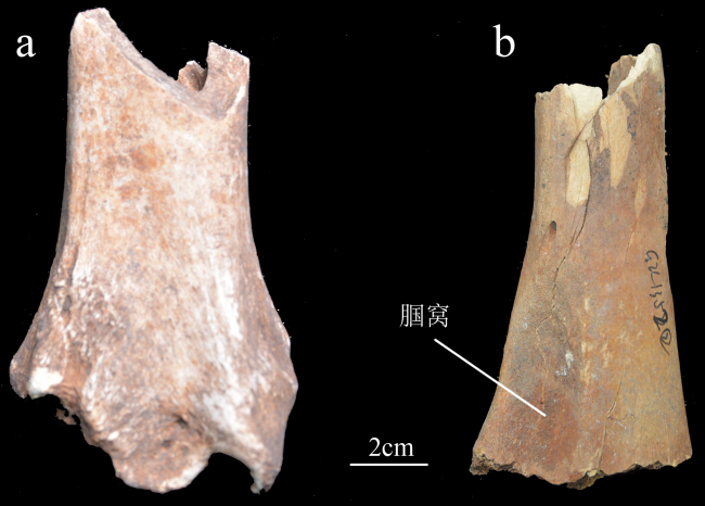
图1 可鉴定的解剖学特征的图例 a.胫骨远端关节面tibia distal articulation;b.股骨腘窝femur supracondylar fossa
Fig.1 The example of identifiable anatomical landmarks
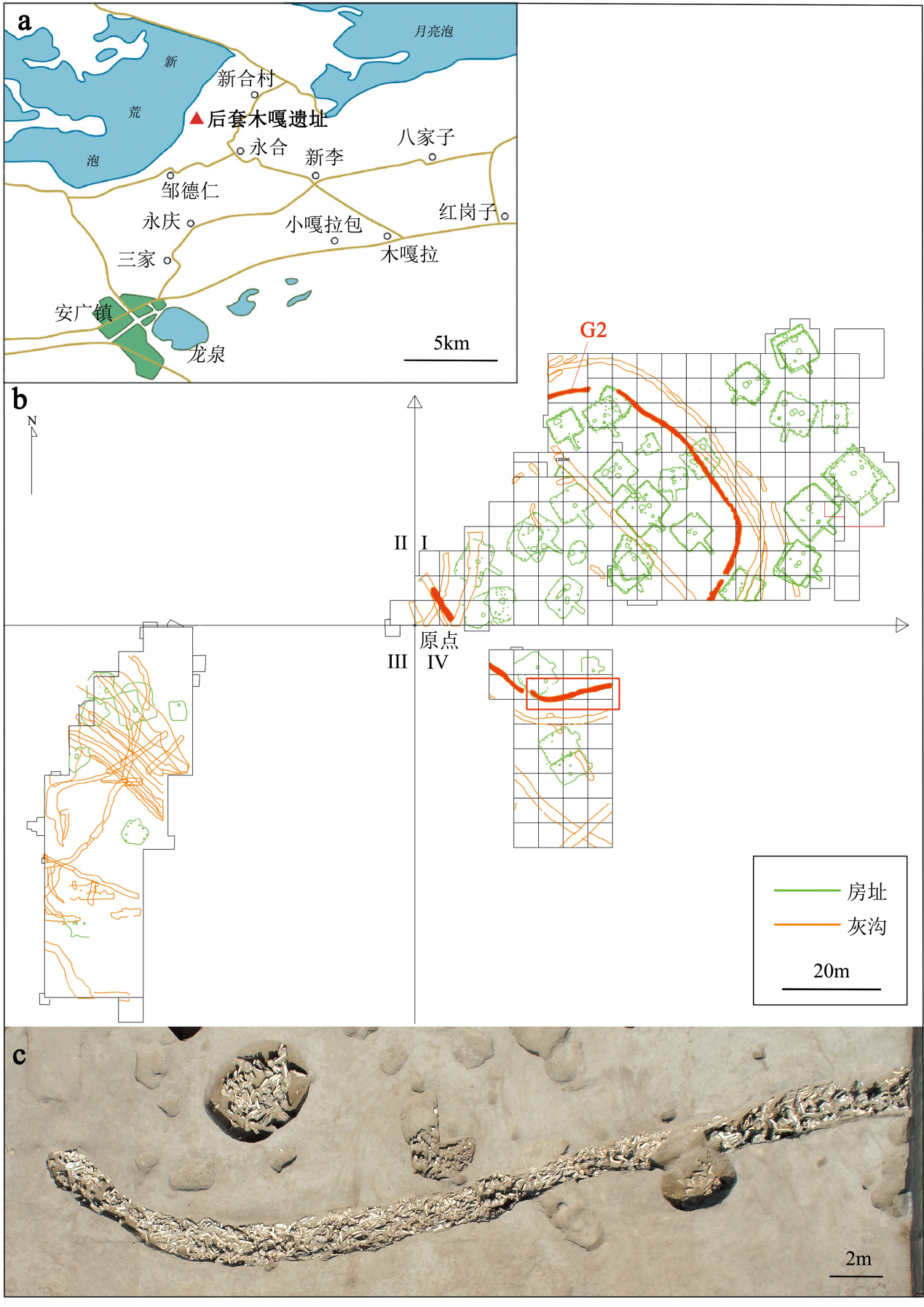
图2 后套木嘎遗址位置图、发掘平面图、G2的航拍图 a.后套木嘎遗址位置示意图,改绘自文献[39]/Location of the Houtaomuga site, modified from reference[39];b.遗址发掘灰沟和房址线图,其中分布在I和IV区的G2(标红的环壕)和房址中出土的原始牛肢骨为本文的研究对象Plan map of ditch and house features, and the aurochs limb bones analyzed in this paper are from the G2 trench (in red) and the house features;c.图b红框中部分G2的航拍图 The aerial image G2 trench (red frame in b)
Fig.2 The location and plan map of Houtaomuga site, and the aerial image of G2 trench
| 可鉴定标本数NISP | 最小骨骼部位数MNE* | 不同皮质骨保存比率的样本数number of different cortical preservation percentage | 烧痕数量number of burn marks** | |||||||||
|---|---|---|---|---|---|---|---|---|---|---|---|---|
| 0~10% | 10%~20% | 20%~30% | 30%~40% | >40% | 轻度light | 中度moderate | ||||||
| G2 | 肱骨humerus | 231 | 177 | 12 | 45 | 51 | 83 | 40 | 25 | 14 | ||
| 桡骨radius | 295 | 143 | 41 | 17 | 54 | 94 | 89 | 45 | 9 | |||
| 掌骨metacarpal | 171 | 95 | 0 | 9 | 18 | 59 | 85 | 32 | 1 | |||
| 股骨femur | 241 | 102 | 50 | 43 | 47 | 61 | 38 | 18 | 18 | |||
| 胫骨tibia | 306 | 162 | 44 | 70 | 96 | 47 | 49 | 40 | 9 | |||
| 跖骨metatarsal | 190 | 100 | 4 | 21 | 38 | 53 | 74 | 36 | 4 | |||
| 总计Total | 1434 | 779 | 151 | 205 | 304 | 397 | 375 | 196 | 55 | |||
| 房址 | 肱骨humerus | 39 | 27 | 7 | 10 | 5 | 9 | 8 | 0 | 0 | ||
| house | 桡骨radius | 44 | 24 | 9 | 4 | 11 | 10 | 10 | 1 | 0 | ||
| features | 掌骨metacarpal | 49 | 26 | 0 | 4 | 6 | 17 | 22 | 2 | 6 | ||
| 股骨femur | 70 | 34 | 14 | 13 | 21 | 17 | 5 | 3 | 6 | |||
| 胫骨tibia | 73 | 40 | 13 | 17 | 16 | 15 | 12 | 4 | 0 | |||
| 跖骨metatarsal | 47 | 26 | 1 | 8 | 11 | 11 | 16 | 1 | 3 | |||
| 总计Total | 322 | 177 | 44 | 56 | 70 | 79 | 73 | 11 | 15 | |||
表1 G2和房址中肢骨的NISP、MNE、不同皮质骨保存比率的样本数和烧灼痕迹数量(n)
Tab.1 The NISP, MNE, number of different cortical preservation percentage, and number of burn marks of limb bones from G2 and house features
| 可鉴定标本数NISP | 最小骨骼部位数MNE* | 不同皮质骨保存比率的样本数number of different cortical preservation percentage | 烧痕数量number of burn marks** | |||||||||
|---|---|---|---|---|---|---|---|---|---|---|---|---|
| 0~10% | 10%~20% | 20%~30% | 30%~40% | >40% | 轻度light | 中度moderate | ||||||
| G2 | 肱骨humerus | 231 | 177 | 12 | 45 | 51 | 83 | 40 | 25 | 14 | ||
| 桡骨radius | 295 | 143 | 41 | 17 | 54 | 94 | 89 | 45 | 9 | |||
| 掌骨metacarpal | 171 | 95 | 0 | 9 | 18 | 59 | 85 | 32 | 1 | |||
| 股骨femur | 241 | 102 | 50 | 43 | 47 | 61 | 38 | 18 | 18 | |||
| 胫骨tibia | 306 | 162 | 44 | 70 | 96 | 47 | 49 | 40 | 9 | |||
| 跖骨metatarsal | 190 | 100 | 4 | 21 | 38 | 53 | 74 | 36 | 4 | |||
| 总计Total | 1434 | 779 | 151 | 205 | 304 | 397 | 375 | 196 | 55 | |||
| 房址 | 肱骨humerus | 39 | 27 | 7 | 10 | 5 | 9 | 8 | 0 | 0 | ||
| house | 桡骨radius | 44 | 24 | 9 | 4 | 11 | 10 | 10 | 1 | 0 | ||
| features | 掌骨metacarpal | 49 | 26 | 0 | 4 | 6 | 17 | 22 | 2 | 6 | ||
| 股骨femur | 70 | 34 | 14 | 13 | 21 | 17 | 5 | 3 | 6 | |||
| 胫骨tibia | 73 | 40 | 13 | 17 | 16 | 15 | 12 | 4 | 0 | |||
| 跖骨metatarsal | 47 | 26 | 1 | 8 | 11 | 11 | 16 | 1 | 3 | |||
| 总计Total | 322 | 177 | 44 | 56 | 70 | 79 | 73 | 11 | 15 | |||
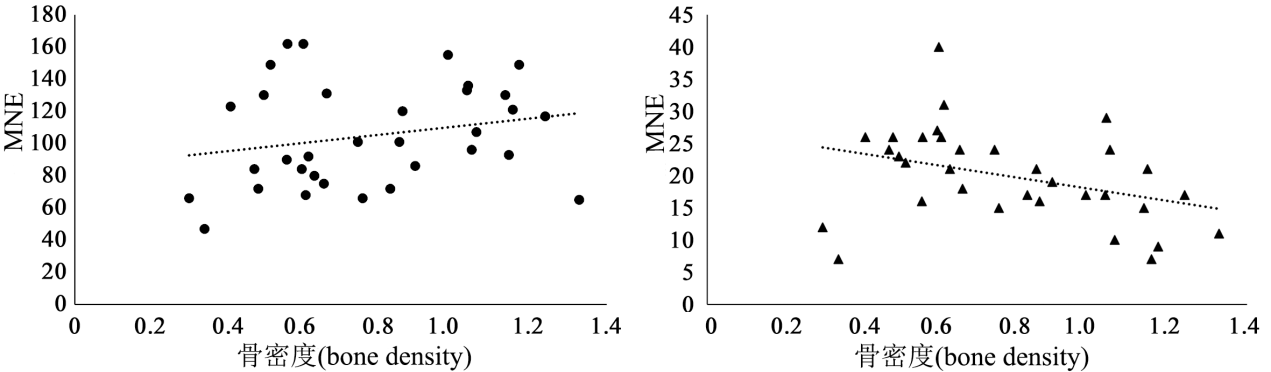
图3 骨骼密度和MNE的散点图 a. G2环壕G2 trench (n=1434);b.房址 house feature (n=322)
Fig.3 The scatterplot of bone density and MNE
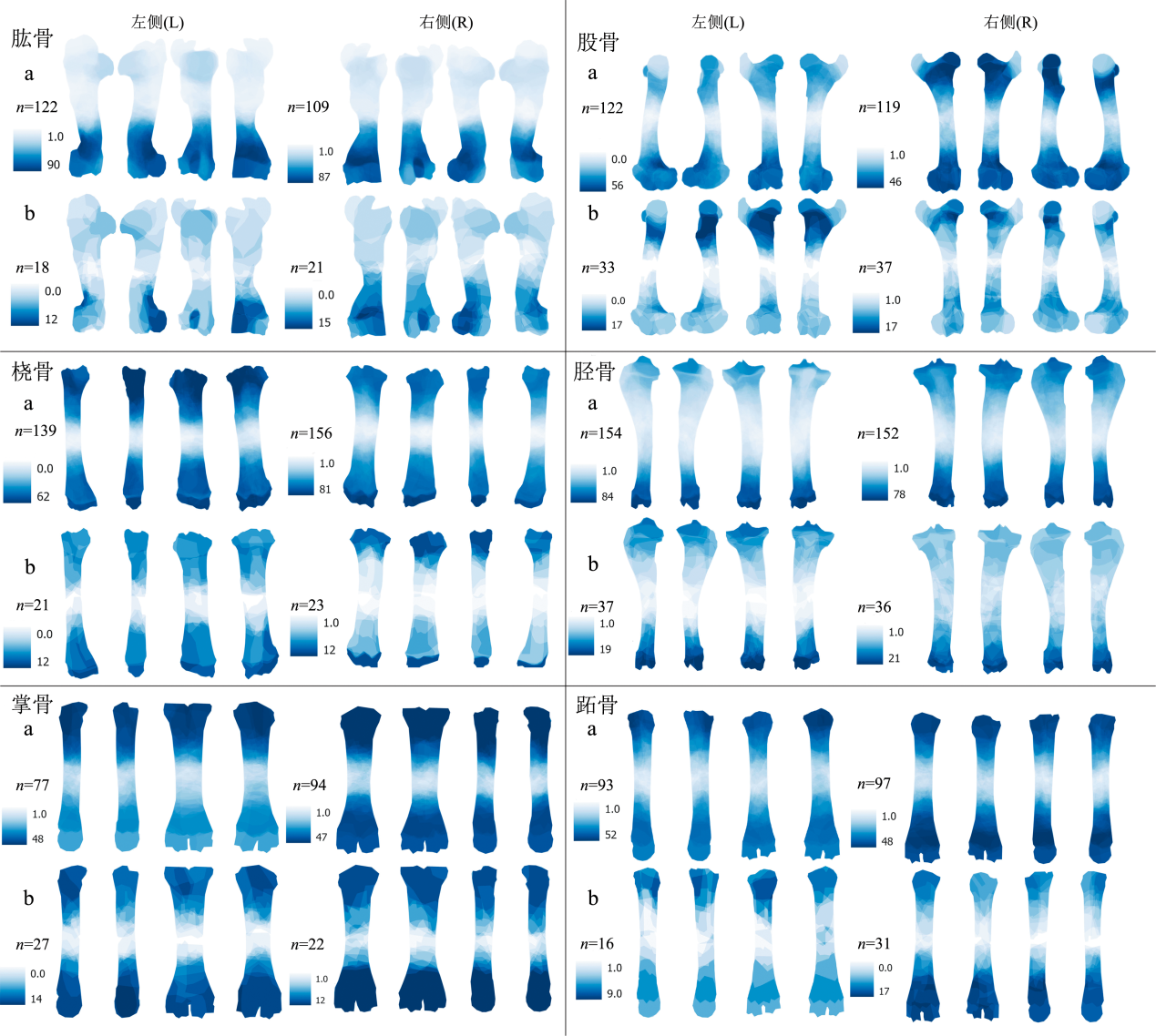
图4 原始牛的肢骨保存率 a. G2环壕G2 trench;b.房址house features。 颜色越深代表保存率越高Dark shaded areas indicate areas of highest survivorship
Fig.4 The survivorship pattern of aurochs limb bones
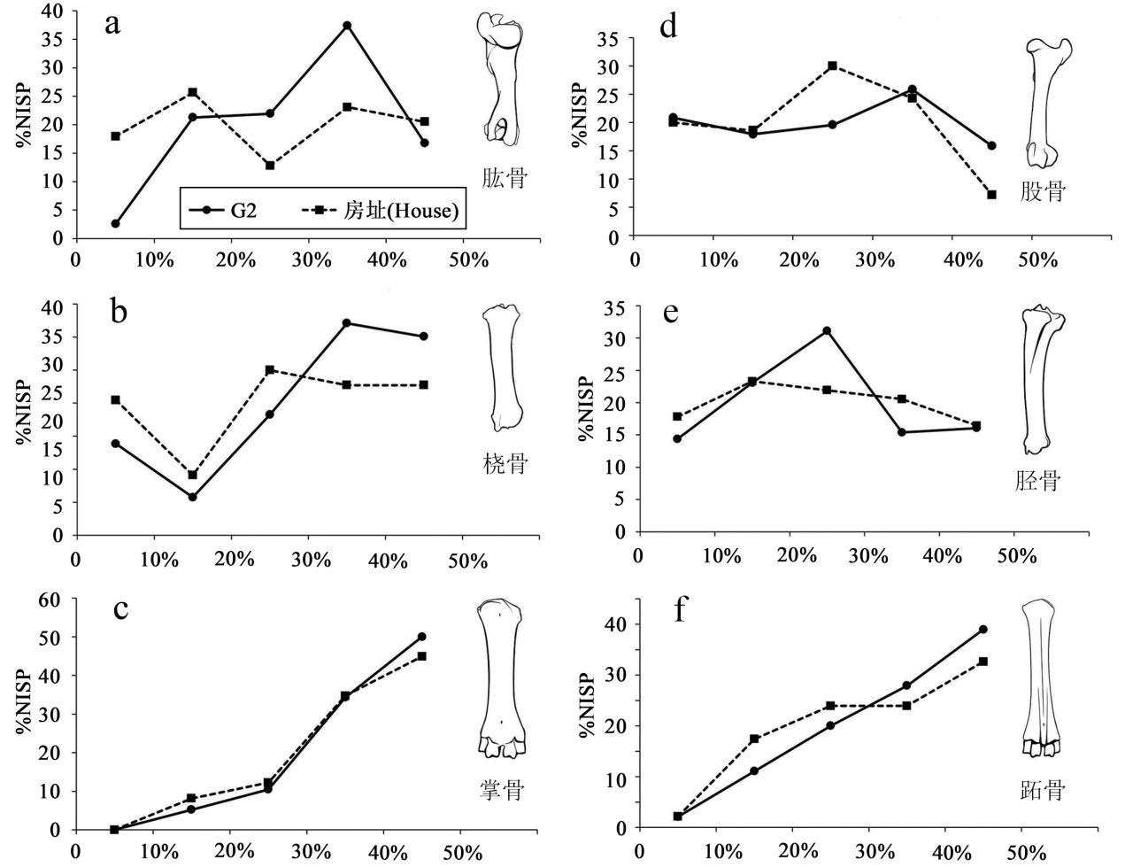
图5 原始牛的皮质骨保存比率 %NISP:可鉴定标本数(NISP)的百分比,此处是不同骨骼保存比率占总骨骼数的百分比the cortical preservation percentage of each limb bones within the total NISP; a.肱骨humerus;b.桡骨radius;c.掌骨metacarpal; d.股骨femur; e.胫骨tibia; f.跖骨metatarsal
Fig.5 The cortical preservation percentage of aurochs limb bones
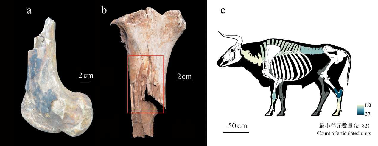
图6 烧灼痕迹标本和原始牛骨骼保留关节相连状态的频率图 a.位于骨骺处的黑色烧灼痕迹The carbonized black mark on bone epiphysis;b.位于骨干中部的斑点状烧灼痕迹The scorched brown mark on mid-shaft;c.关节相连频率图(n=82) The frequency map of bone articulation
Fig.6 The specimens of burn marks and the frequency map of aurochs bone articulation
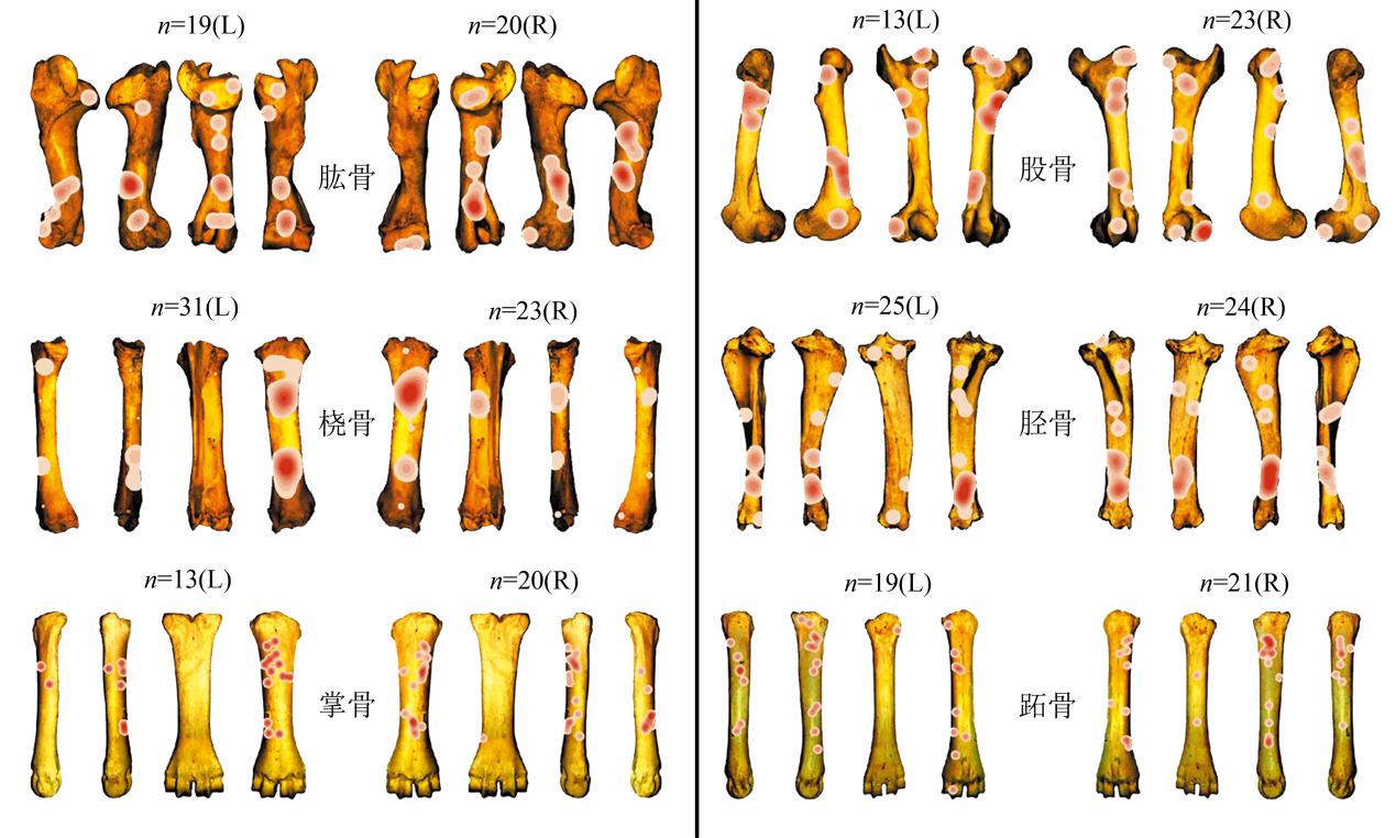
图7 G2出土原始牛肢骨烧灼痕迹的核密度分布图 颜色越深代表集中程度越高
Fig.7 The kernel density map of burning marks on aurochs limb bones from G2 dark red areas indicate the highest concentrations of burn marks
| [1] |
Kvamme KL. Recent directions and developments in Geographical Information Systems[J]. Journal of Archaeological Research, 1999, 7: 153-201
doi: 10.1007/s10814-005-0002-9 URL |
| [2] | Bolstad P. GIS fundamentals: a first text on Geographic Information Systems[M]. XanEdu Publishing Inc, 2016 |
| [3] | Sanz FQ, Preysler JB, Bosqued CB.An application of GIS to intra-site spatial analysis: the Iberian Iron Age cemetery of El Cigarraleijo (Murcia, Spain)[A]. In: Huggett J, Ryan N. Computer applications and quantitative methods in archaeology[C]. BAR International Ser.600, Oxford, 1994, 137-146 |
| [4] |
Kealy S, Louys J, O’Connor S. Least-cost pathway models indicate northern human dispersal from Sunda to Sahul[J]. Journal of Human Evolution, 2018, 125: 59-70
doi: S0047-2484(18)30213-6 pmid: 30502898 |
| [5] |
Kantner J, Hobgood R. A GIS-based viewshed analysis of Chacoan tower kivas in the US Southwest: were they for seeing or to be seen?[J]. Antiquity, 2016, 90: 1302-1317
doi: 10.15184/aqy.2016.144 URL |
| [6] | 刘岩. 地理信息系统在中国史前考古学中应用的回顾与反思[J]. 南方文物, 2017, 4: 224-233 |
| [7] | 曹兵舞. GIS与考古学[J]. 考古与文物, 1997, 4: 79-84 |
| [8] | 高立兵. 时空解释新手段:欧美考古GIS研究的历史、现状和未来[J]. 考古, 1997, 7: 89-95 |
| [9] | 中国河南省文物考古研究所, 美国密苏里州立大学人类学系. 河南颍河上游考古调查中运用GPS与GIS的初步报告[J]. 华夏考古, 1998, 1: 1-16 |
| [10] | 中美两城地区联合考古队. 山东日照两城地区的考古调查[J]. 考古, 1997, 4: 1-15 |
| [11] | 中国社会科学院考古研究所, 美国明尼苏达大学科技考古实验室, 中美洹河流域考古队. 洹河流域区域考古研究初步报告[J]. 考古, 1998, 10: 13-22 |
| [12] | 赤峰中美联合考古项. 内蒙古东部(赤峰)区域考古调查阶段性报告[M]. 北京: 科学出版社, 2003 |
| [13] | 陈星灿, 刘莉, 李润权, 等. 中国文明腹地的社会复杂化进程:伊洛河地区的聚落形态研究[J]. 考古学报, 2003, 2: 161-218 |
| [14] | 朔知, 丁见祥, 罗虎.金山县凌家滩遗址周边考古调查[A].见:中国考古学会(编),中国考古学年鉴(2009)[C]. 北京: 文物出版社, 2010 |
| [15] | 中国国家博物馆田野考古研究中心, 山西省考古研究所, 运城市文物保护研究所. 运城盆地东部聚落考古调查与研究[M].文物出版社, 2011 |
| [16] | 中国国家博物馆考古部. 垣曲盆地聚落考古研究[M]. 北京: 科学出版社, 2007 |
| [17] | 张强. 长江三角洲地区新石器时代环境演变对人类活动影响研究[D]. 博士学位论文, 南京: 南京大学, 2003 |
| [18] | 黄润. 安徽淮河流域新石器时代环境考古研究[D]. 博士学位论文, 南京: 南京大学, 2005 |
| [19] | 滕铭予. GIS支持下的赤峰地区环境考古研究[M]. 北京: 科学出版社, 2009 |
| [20] | 张海. ArcView地理信心系统在中原地区聚落考古研究中的应用[J]. 华夏考古, 2004, 1: 98-106 |
| [21] | 乔玉. 伊洛地区裴李岗至二里头文化时期复杂社会的演变:地理信息系统基础上的人口和可耕地分析[J]. 考古学报, 2010, 4: 423-454 |
| [22] | 李新伟. 地理信息系统支持的兴隆洼文化手工业生产专业化研究[J]. 考古, 2008, 6: 58-68 |
| [23] |
Marean CW, Abe Y, Nilssen PJ, et al. Estimating the minimum number of skeletal elements (MNE) in zooarchaeology: a review and a new image-analysis GIS approach[J]. American Antiquity, 2001, 66(2): 333-348
pmid: 20043371 |
| [24] | Lyman RL. Quantitative paleozoology[M]. Cambridge University Press, 2008 |
| [25] | Garcia-Moreno A, Hutson MJ, Villauenga A, et al. Counting sheep without falling asleep: using GIS to calculate the minimum number of skeletal elements (MNE) and other archaeozoological measures[A]. In: Giligny F, Djindjian F, Costa L, et al. CAA2014: 21st Century Archaeology: Concepts, methods and tools[C]. Proceedings of the 42nd Annual Conference on Computer Applications and Quantitative Methods in Archaeology, 2005, 407-412 |
| [26] |
Parkinson JA. Revisiting the hunting-versus-scavenging debate at FLK Zinj: a GIS spatial analysis of bone surface modifications produced by hominins and carnivores in the FLK 22 assemblage, Olduvai Gorge, Tanzania[J]. Palaeogeography, Palaeoclimatology, Palaeoecology, 2018, 511: 29-51
doi: 10.1016/j.palaeo.2018.06.044 URL |
| [27] |
Abe Y, Marean CW, Nilssen PJ, et al. The analysis of cutmarks on archaeofauna: a review and critique of quantification procedures, and a new image-analysis GIS approach[J]. American Antiquity, 2002, 67: 643-664
doi: 10.2307/1593796 URL |
| [28] |
Parkinson JA, Plummer TW, Hartstone-Rose A. Characterizing felid tooth marking and gross bone damage patterns using GIS image analysis: an experimental feeding study with large felids[J]. Journal of Human Evolution, 2015, 80: 114-134
doi: 10.1016/j.jhevol.2014.10.011 pmid: 25467112 |
| [29] |
Parkinson JA, Plummer TW, Bose R. A GIS-based approach to documenting large canid damage to bones[J]. Palaeogeography, Palaeoclimatology, Palaeoecology, 2014, 409: 57-71
doi: 10.1016/j.palaeo.2014.04.019 URL |
| [30] |
Stavrova T, Borel A, Daujeard C, et al. A GIS based approach to long bone breakage patterns derived from marrow extraction[J]. PLoS ONE, 2019, 14(5): e0216733
doi: 10.1371/journal.pone.0216733 URL |
| [31] | 张乐, 张双权, 高星. 地理信息系统在动物考古学研究中的应用:以贵州马鞍山遗址出土的动物遗存为例[J]. 人类学学报, 2019, 38(3): 407-418 |
| [32] |
Baxter MJ, Beardah CC. Some archaeological applications of Kernel Density estimates[J]. Journal of Archaeological Science, 1997, 24: 347-354
doi: 10.1006/jasc.1996.0119 URL |
| [33] | Brain CK. Hottentot food remains and their bearing on the interpretation of fossil bone assemblages[J]. Scientific Papers of the Namib Desert Research Station, 1967, 32: 1-11 |
| [34] | Guthrie RD. Differential preservation and recovery of Pleistocene large mammal remains in Alaska[J]. Journal of Paleontology, 1967, 44(1): 243-246 |
| [35] |
Lyman RL. Bone density and differential survivorship of fossil classes[J]. Journal of Anthropological archaeology, 1984, 3(4): 259-299
doi: 10.1016/0278-4165(84)90004-7 URL |
| [36] | 王立新. 后套木嘎新石器时代遗存及相关问题研究[J]. 考古学报, 2018, 2: 141-161 |
| [37] | 吉林大学边疆考古研究中心, 吉林省文物考古研究所. 吉林大安市后套木嘎遗址AIV区发掘简报[J]. 考古, 2017, 11: 3-30 |
| [38] |
Cai D, Zhang N, Zhu S, et al. Ancient DNA reveals evidence of abundant aurochs (Bos primigenius) in Neolithic Northeast China[J]. Journal of Archaeological Science, 2018, 98: 72-80
doi: 10.1016/j.jas.2018.08.003 URL |
| [39] |
Blumenschine RJ. An experimental model of the timing of hominid and carnivore influence on archaeological bone assemblages[J]. Journal of Archaeological Science, 1988, 15: 483-502
doi: 10.1016/0305-4403(88)90078-7 URL |
| [40] |
Blumenschine RJ. Percussion marks, tooth marks, and experimental determinations of the timing of hominid and carnivore access to long bones at FLK Zinjanthropus, Olduvai Gorge, Tanzania[J]. Journal of Human Evolution, 1995, 29: 21-51
doi: 10.1006/jhev.1995.1046 URL |
| [41] | Driver HE. Indians of North America[M]. The University of Chicago Press, 1972 |
| [42] | Brink J. Imagining Head-Smashed-In: Aboriginal buffalo hunting on the northern plains[M]. Athabasca University Press, 2008 |
| [43] |
Brink J. Fat content in leg bones of Bison bison, and applications to archaeology[J]. Journal of Archaeological Science, 1997, 24(3): 259-274
doi: 10.1006/jasc.1996.0109 URL |
| [44] |
Carroll EL, Martin S. Burning questions: investigations using field experimentation of different patterns of change to bone in accidental vs deliberate burning scenarios[J]. Journal of Archaeological Science: Reports, 2018, 20: 952-963
doi: 10.1016/j.jasrep.2018.02.001 URL |
| [45] | Ellingham ST, Thompson TJ, Islam M, et al. Estimating temperature exposure of burnt bone: A methodological review[J]. Science & Justice, 2015, 55(3): 181-188 |
| [46] |
Stiner MC, Kuhn SL, Weiner S, et al. Differential burning, recrystallization, and fragmentation of archaeological bone[J]. Journal of Archaeological Science, 1995, 22(2): 223-237
doi: 10.1006/jasc.1995.0024 URL |
| [47] |
Shaffer BS. Interpretation of gopher remains from southwestern archaeological assemblages[J]. American Antiquity, 1992, 57(4): 683-691
doi: 10.2307/280829 URL |
| [48] | Albarella U, Serjeantson D.A passion for pork: meat consumption at the British Late Neolithic site of Durrington Walls[A]. In: Milner N, Miracle P. Consuming passions and patterns of consumption[C]. McDonald Institute for Archaeological Research, 2002, 33-50 |
| [49] | Ingstad H. Nunamiut: Among Alaska’s Inland Eskimo[M]. George Allen and Unwin, London, 1954 |
| [50] | Binford LR. Bones: Ancient Men and Modern Myths[M]. Academic Press, New York, 1981 |
| [51] | Langley A, Wisher I. Have you got the tine? Prehistoric methods in antler working[J]. EXARC Journal, 2019, 2 |
| [52] |
Moclán A, Domínguez-Rodrigo M. An experimental study of the patterned nature of anthropogenic bone breakage and its impact on bone surface modification frequencies[J]. Journal of Archaeological Science, 2018, 96: 1-13
doi: 10.1016/j.jas.2018.05.007 URL |
| [1] | 阮齐军, 李田广, 车德才, 和金梅, 孙博阳, 史勤勤, 侯素宽, 张双权, 王国付, 李俊, 永春, 张飞, 石俊雯, 张雯静, 贾真秀, 李浩. 云南元谋猿人遗址2023年度发掘报告[J]. 人类学学报, 2025, 44(06): 939-951. |
| [2] | 曹雨昕, 孙璐, 张乐, 张双权. 骨骼表面人类齿痕特征的实验研究[J]. 人类学学报, 2025, 44(02): 242-254. |
| [3] | 王颖, 张乐, 杨石霞, 张双权. 山西峙峪遗址出土动物骨骼的埋藏学[J]. 人类学学报, 2025, 44(02): 255-269. |
| [4] | 支媛, 杜水生, 刘吉颖. 南非石器时代中期人类对动物资源的开发[J]. 人类学学报, 2025, 44(02): 352-364. |
| [5] | 杜雨薇, 张乐, 叶芷, 裴树文. 蔚县盆地吉家庄旧石器遗址动物骨骼的埋藏学分析[J]. 人类学学报, 2023, 42(03): 359-372. |
| [6] | 侯彦峰, 张建, 曹艳朋, 靳松安. 河南淅川沟湾遗址仰韶时期的动物遗存[J]. 人类学学报, 2022, 41(05): 913-926. |
| [7] | 武仙竹, 陈育芝, Drozdov NI. 西伯利亚李斯特文卡遗址的大缺齿鼹化石[J]. 人类学学报, 2021, 40(06): 1032-1040. |
| [8] | 黄超, 张双权. X射线衍射技术在烧骨实验研究中的初步应用[J]. 人类学学报, 2021, 40(03): 513-525. |
| [9] | 戴静雯, 张双权, 张乐. 史前人类对动物骨骼油脂的开发和利用[J]. 人类学学报, 2021, 40(03): 503-512. |
| [10] | 黄超, 张双权. 旧石器遗址出土烧骨的技术分析及其对考古学的启示[J]. 人类学学报, 2020, 39(02): 249-260. |
| [11] | 梁琪瑶, 陈全家, 王春雪. 吉林大安市后套木嘎遗址出土鸟类遗存研究[J]. 人类学学报, 2020, 39(01): 118-126. |
| [12] | 张双权, 宋艳花, 张乐, 许乐, 李磊, 石金鸣. 柿子滩遗址第9地点出土的动物烧骨[J]. 人类学学报, 2019, 38(04): 598-612. |
| [13] | 张乐, 张双权, 高星. 地理信息系统在动物考古学研究中的应用: 以贵州马鞍山遗址出土的动物遗存为例[J]. 人类学学报, 2019, 38(03): 407-418. |
| [14] | 张双权, 彭菲, 张乐, 郭家龙, 王惠民, 黄超, 戴静雯, 张钰哲, 高星. 宁夏鸽子山遗址第10地点出土动物骨骼的埋藏学初步观察[J]. 人类学学报, 2019, 38(02): 232-244. |
| [15] | 武仙竹;王照魁. 重庆丰都瓦啄嘴遗址的小哺乳动物[J]. 人类学学报, 2018, 37(03): 452-466. |
| 阅读次数 | ||||||
|
全文 |
|
|||||
|
摘要 |
|
|||||
 京ICP证05002819号-3